61 km of wilderness in the Purcell Mountains are to master, 1525 vertical meters to ascend and Hamill Creek to cross multiple times. From day three onward the trail disappears into bush and the hike becomes a fight through shrub and underwood, across stone avalanches and within oneself.

Crossing Hamill Creek Conveniently by Cable Car
But then?
How to Get to the Other Side?
The group started in Argenta on a warm and sunny day in mid July. Spring 2002 had been very wet, mountain ranges were still covered with snow, and creeks were flowing wild. Kooteny summer only came a few days before the hike started.
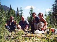
Take a Break
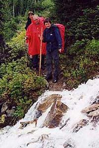
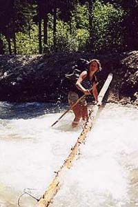
When the last cable car is passed at km 27 crossing becomes a test. Sometimes it is possible by balancing on slippery logs and at places where there are no logs, walking through the raging creek is the only way across. Then the only security is a fallen tree which has to be found and placed as a hand rail over the creek.
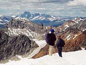
After km 35 the trail begins to ascend dramatically and nobody in the group regretted that the weight of their backpacks had dropped significantly. It was day four and just that day as they neared the pass, the weather, which had been fine so far, changed to rain and fog. The group decided not to camp on top of the pass at 2286m, but instead descend the other side towards Toby Creek.
They all regretted not being able to climb Slate Peak and enjoy the incredible views of Hamill and Horseshoe Glacier one has from here on a clear day. But they got reimbursed on day five when the weather cleared again. Their last night was spent under an almost unreal heaven totally covered stars. Nobody spoke much but everybody agreed when Marion said: "This night is so wonderful for sure we will never ever forget it."
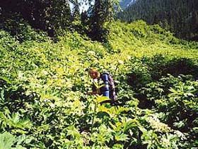
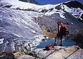
Henry’s van carried the group back to Meadow Creek via rough Mary’s Lake, Redding Creek and Gray Creek logging road which just had been opened for summer travel. Some days of relaxation and swimming in Duncan Lake followed. But soon everybody craved for the next hike. Visiting the alpine basin of Meadow Mountain with the wild flowers in full bloom was spectacular but easy. As an encore they took their last day in the region to hike up McBeth Icefield and enjoyed incredible vistas over the whole area.
"We are coming back next year for sure", Andreas promised at their farewell and Marion added: "So what are your suggestions for the next week of backcountry hiking?" "Nothing easier than that", Henry laughed. "What about the Valhalla Traverse, a real challenge?" "OK." The decision was made.
Elisabeth von Ah
|

Our Hikers crossing Kootenay Lake
It is believed that Chief Kinbasket, head of the Shuswap Indian band, brought the first white men through this area. In the early years of the 19th century, when the news about treasures of the soil spread and attracted thousands of miners, he guided the newcomers along Hamill Creek and over the Purcell mountains. Their route went from an area near present-day Invermere to Argenta on the east shore of Kootenay Lake. The trail, named after the British Lord Earl Grey, became an important route to bring supplies by pack trains into the area; even cattle were driven over the mountains from Invermere to the Lardeau Valley. Impressed by the beauty of the Purcells, Lord Earl Grey built a cabin for his family in 1909 near today’s eastern trailhead at Toby Creek. Remains of the cabin still stand after nearly a hundred years.
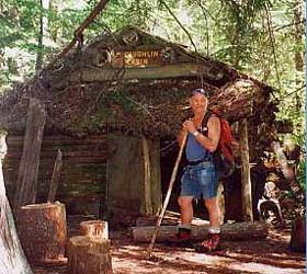
McLaughlin Cabin
For Marion, Andreas and Hartmut from Hamburg, Germany, who have hiked in the Kootenays several times before, Earl Grey Pass Trail became the highlight of their summer vacation in 2002. Henry, a Swiss outdoorsman living in Canada for 35 years, joined their group. While Marion and Hartmut organized the food plan, Andreas and Henry shuttled Henry’s van to the end of their hike. With two vehicles and two lake crossings by ferry the 1500km long drive consumed considerable time and gas.
By GPS Andreas discovered later that the direct distance between start and end of the trail through air is only a little more than 30km. This proves the importance of the trail in pioneer days.
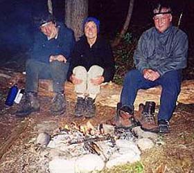
Romantic Evenings by the Camp Fire
The trail begins with slow ascends through a dense cedar forest. Remains of old cabins and mining machinery tell about the past, and it is amazing, how much effort the miners had to put in to get the ore with the technical ability a hundred years ago. Again and again the trail crosses Hamill Creek. The first six crossings by cable car are easy and fun.
Bushwacking
Before Ascending McBeth Icefield
Vistas from Top of McBeth Icefield |